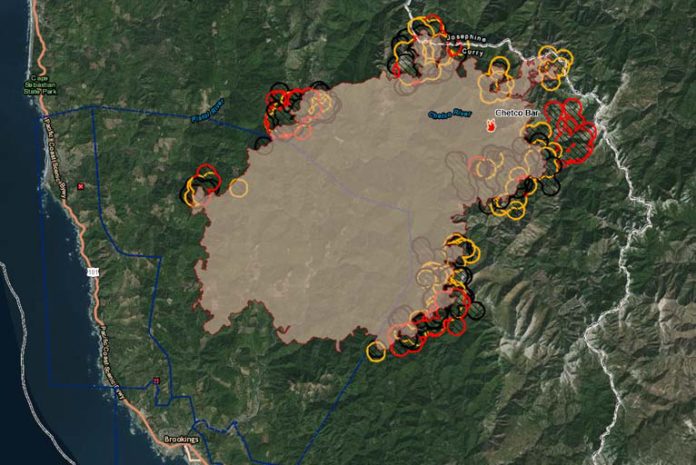
On Monday evening August 28th, 2017, authorities updated the Chetco Bar Fire situation. As of approximately 8:30 PM, the Chetco Bar FIre had blackened over 117,670 acres, adding more than 9,000 acres on Monday.
The Johnson Butte and north in the Tincup Pass and Tincup Creek areas proved to be the most active areas Monday. Several areas on the north, south and eastern perimeter also showed significant growth as the result of extreme torching, spotting, and short crown runs. A “crown run” is when a fire advances from top to top of trees or shrubs more or less independently of a surface fire.
Hot, very dry, and unstable mid-level Haines 6 conditions occurred over the fire again on Monday. The “Haines Index” also known as Lower Atmosphere Severity Index measures the potential for dry, unstable air that contributes to the development of large or erratic wild land fires.
Monday night into Tuesday morning is expected to be a repeat of last night, with subsidence inversions likely to result in another warm night with temperatures around 80 degrees and very low humidity along and above thermal belts. A subsidence inversion develops when a widespread layer of air is compressed and heated by the resulting increase in atmospheric pressure.
South-southwest winds were predicted to be stronger on the ridge tops Monday night, but gusts will generally remain 20mph or less. A weak weather disturbance may deepen the marine layer slightly overnight. Over the next two days, officials are preparing for a critical burn environment with a high potential for extreme fire behavior with more torching, spotting, flanking, possible crown runs and plume development depending on the accuracy of weather predictions.
The approximately 1500 personnel fighting the enormous fire complex continue building and reinforcing direct and indirect containment lines. Continued structure protection efforts, hose laying, removal of flammable materials and road improvements for fire lines were just some of the efforts performed by fire crews over the past few days. Scouting areas for new containment lines have been performed by fire crews over the past few days.
At approximately 11:00 AM, Monday August 28th, 2017, authorities announced a Chetco Bar Fire Evacuation Re-Entry Plan to residents and businesses of the South Bank Chetco River.
The announcement stated that all residences and businesses within the current Level 3 Evacuation zone starting at the junction of Shady Lane and South Bank Chetco River Road east to and including Freeman Rock and Salmon Run golf course will be reduced to a Level 2 Evacuation. The area involved also included residents in the Campbell and Harbor Hills road area.
All residents that live in this geographic area are asked to present their picture identification to Curry County Sheriff’s Office staff to receive re-entry materials.
The Level 3 Evacuation Order remains in effect along Carpenterville Road which lies north of Bosley Butte Road along Summit Ridge and north to Sundown Mountain. Residents within this area should leave immediately. The danger to your area is current or imminent, and you should evacuate immediately.
Displaced residents may relocate to an emergency evacuation shelter at Riley Creek Elementary in Gold Beach 94350 6th St. Gold Beach, OR. (541)-600-6068. Travelers in campers and motels are asked to relocate elsewhere along the Oregon coast. Residents should make arrangements to move property and livestock. People with special health needs or other concerns should relocate during the warning.


