


Curry County Emergency Management issued a Weather Advisory Monday afternoon regarding the strong storm system that has developed over the eastern Pacific and is expected reach the West Coast by late Tuesday afternoon. This low pressure system will likely undergo a “bombogenesis” (pressure drop of at least 24mb in 24 hours) from Monday night to Tuesday night, at which point it could become a 980mb low with hurricane force winds offshore.
It should reach land near the California/Oregon border early Tuesday night and then begin to gradually weaken as it moves inland. The mountains of southern Oregon and northern California are likely to get hammered with blizzard conditions, and battering surf and high winds for coastal areas. Winter storm watches and warnings are already in effect for many of these areas, and the cold nature of the event will result in lower than usual snow levels. Pre-Thanksgiving travel in this region could be severely affected, and local forecast offices have additional information pertaining to this.
This low is unprecedented in its strength and track. Storms of this magnitude have not been observed on this track in the last 15 to 20 years or more.
The low is forecast to rapidly deepen 30mb in 12 hours as it approaches the Southern Oregon Coast on Tuesday. The low is forecast to become positioned off the Curry Coast Tuesday afternoon then move on shore Tuesday evening and inland over the area Tuesday night into Wednesday morning. Significant impacts are expected from heavy snow and high winds.
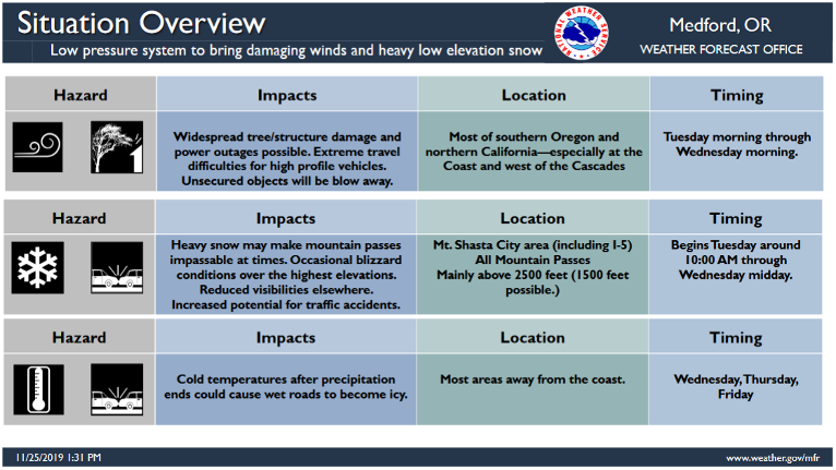
The location of the highest winds will largely depend on the exact track of the low. Small shifts in the track will make a difference in which areas see very strong winds. Overall, the majority of the models and ensembles are bringing a 970 to 975mb low into the Curry Coast on Tuesday. So there is high confidence in very strong winds occurring at the coast and inland over Siskiyou County and into Jackson and Josephine Counties as well as over the higher mountains. High wind warnings are in effect.
Coastal waters are expected see strong storm force winds with periods of hurricane-force gusts. Strong storm force winds over the waters will initially be southerly then quickly switch to strong northerly winds behind the low Tuesday night. This will bring extremely steep and very dangerous seas to the coastal waters. Additionally, high surf is expected along with all coastal areas of Southern Oregon.
Travel is strongly discouraged because of dangerous conditions. *If you must travel, keep tire chains a flashlight, blankets, food, water, medications and a fully charged phone with you. *The safest place during a storm is indoors. *A winter storm warning means that severe weather is likely and poses a threat to life and property. Take protective action now.
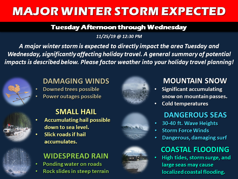
Potentially historic wind storm expected Tuesday afternoon and evening. A highly unusual, rapidly deepening Pacific storm system is expected to make landfall on the southern Oregon coast Tuesday evening. This change in surface low pressure could be potentially be one of the deepest recorded in recent memory, it will produce very strong winds across the region particularly at the coast, including Curry County, over the area ridgelines, and in the valleys of Josephine, Jackson, and Siskiyou counties.
South winds 35 to 55 mph with gusts up to 75 mph expected from 10:00am Tuesday thru 1:00am Wednesday through out South Central Oregon Coast and Curry County Coast, including Highway 101 and the cities of Brookings, Gold Beach, Port Orford, Bandon, Coos Bay, Myrtle Point and Coquille. Winds will shift to the north in the evening. Headlands and exposed areas could see gusts in excess of 100mph.
People should avoid being outside in forested areas and around trees and branches. If possible, remain in the lower levels of your home during a windstorm, and avoid windows. Use caution if you must drive.
Damaging winds will blow down trees and power lines. Widespread power outages are possible. Travel will be difficult, especially for high profile vehicles. Unsecured outdoor objects may be blown away or damaged.
A High Surf Advisory remains in effect from 1 a.m. Tuesday to 10 a.m. Wednesday for South Central Oregon Coast-Curry County Coast.
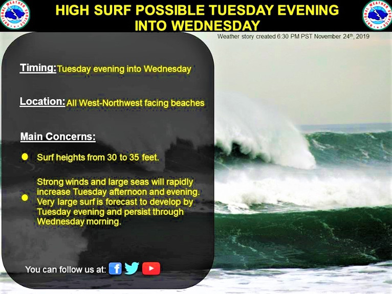
Historically strong storm arrives Tuesday. A historically strong low pressure system will bring rapidly rising waves Tuesday. Strong south winds will bring high surf to area beaches, especially south facing beaches like Port Orford and Brookings. Winds will shift to northerly Tuesday night.
Surf heights ranging from 24 feet north of Cape Blanco to near 35 feet south of Gold Beach
High Surf will cause high wave run ups, storm surge of several feet, and potential beach erosion. Infrastructure at Port Orford and Brookings could see damage from the waves. Stay away from the ocean and any jetties during this event. Shock and hypothermia can occur quickly in the cold Pacific waters.
A High Surf Advisory means that high surf will affect beaches in the advisory area, producing rip currents and localized beach erosion. Avoid going on rocks and jetties. Never turn your back on the ocean!