


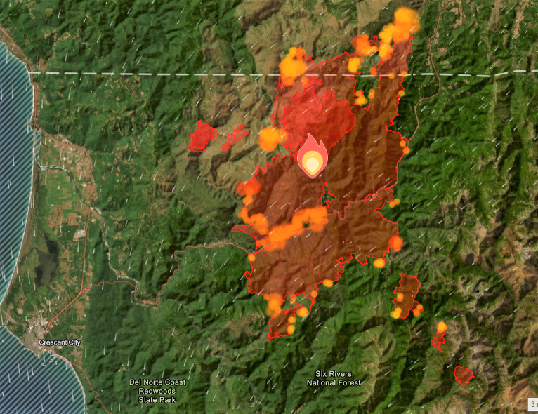
Fire authorities from the Smith River Fire Complex reported Tuesday that fire crews continued to race time in efforts to contain and secure as much of the perimeter of the fires before conditions change to unfavorable, near critical fire weather pattern forecast to starting early Wednesday morning as the blaze consumed another 4,550 acres, growing to over 75,775 total acres with 7% containment.
U.S. Hwy. 199 remains closed and the planned limited opening scheduled to begin Wednesday morning has been cancelled and has tentatively been postponed to Wednesday, August 30th, due to the continued closure and Level 3 evacuation in O’Brien Oregon.
Engines and hotshot crews have put together an extensive effort to construct control line, plumb it with hose, and successfully control burn the nearly 1-mile of line in steep rugged terrain in efforts to keep the fire from continuing to progress westward to structures.

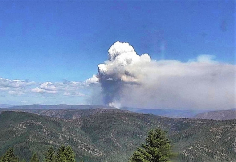
Helicopters continue to be grounded from helping with suppression efforts due to heavy thick smoke now for several days, however, Unmanned Aerial Systems, drones, equipped with infrared sensors have proven to be an invaluable asset in locating several small spot fires not visible through dense smoke and assisting fire personnel to locate and extinguish these fires quickly.

Currently assigned resources include 2,780 total personnel, 65 crews, 5 helicopters, 216 engines, and 29 dozers of heavy equipment, and 22 Water Tenders with more resources requested and arriving at the Smith River Complex.
Tuesday was forecast as transition day for fire weather as stronger afternoon northwest winds subsided Tuesday evening into Wednesday morning before a shift to an offshore direction that could bring a period of near critical fire weather conditions Wednesday with stronger winds and drier relative humidity. Fire resources have been working hard in preparation for this event, including staffing a robust night shift who will be focusing on holding around structures.
All evacuation orders are issued by the Del Norte County Sheriff’s Office. If you are in the Del Norte County, area please sign up for their Community Alert System to receive emergency notifications. Evacuation levels as of August 27th include
Level 3 “Go Now”: Patrick Creek, Little Jones Creek, Copper Creek Drainage, Coon Creek/ 16n19 17n07, Washington Flat, Pioneer Road, Panther Flat Campground Area, all communities between Slant Bridge Road north to the Oregon Border along Highway 199, French Hill Road and from the Hwy 199 area south of O’Brien from milepost 38 to the state line
Level 2 “Be Set”: “Be Set”: Low Divide, High Divide, Rowdy Creek, Big Flat/Rock Creek as well as O’Brien and the Takilma area.
Level 1 “Be Ready”: Hiouchi from Slant Bridge to the east end of North Bank Road and north to Cave Junction.