


With Red Flag Warnings forecasting a relatively dry weather system threatening Thunder and Lightning storms through out Thursday evening and into Friday morning looming, fire crews scrambled Thursday to secure fire line and protect structures. With those efforts in place, the Smith River Fire Complex expanded another 9,280 acres to know 66,505 acres since Thursday morning with 0% containment.
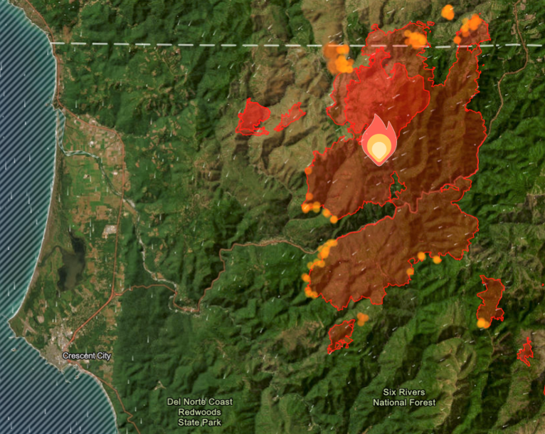
U.S. Hwy. 199 will remain fully closed in Del Norte County from Slant Bridge Road to Oregon Mountain Road and at the Agriculture Station near the Oregon border.
Fire personnel were again unable to conduct aerial operations on the north end of the Kelly Fire allowing work on fire lines west of Hwy 199, as other fire personnel began setting up sprinkler systems to provide further protection for structures.

Preparation efforts continued in and around the town of Gasquet throughout the day controlled burns were conducted along the Highway 199 utilizing Hot Shot crews and Unmanned Aerial Systems allowing Pacific Power and Caltrans access to affected areas to repair valuable infrastructure.
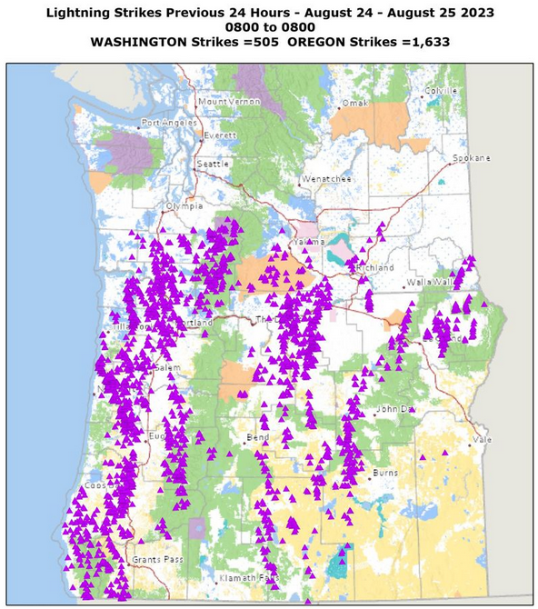
As forecast, Thursday evening into Saturday morning, more than 1,633 lightning strikes struck across Oregon featuring bringing wind gusts up to 35 mph, and some scattered showers that helped keep fire activity less than what was predicted. A spot fire was detected but was quickly extinguished by firefighters patrolling the area.
With field crews working around the clock, Pacific Power has now restored power to nearly all customers in the Crescent City and Del Norte County area using large generators. The Gasquet and Patrick Creek areas remain without power due to Level 3 evacuation orders from Del Norte County.
All evacuation orders are issued by the Del Norte County Sheriff’s Office. If you are in the Del Norte County, area please sign up for their Community Alert System to receive emergency notifications. Evacuation levels as of August 25th,
Level 3 “Go Now”: Low Divide at Highway 197 from mile marker 1 to mile marker 13. Patrick Creek, Little Jones Creek, Copper Creek Drainage, Coon Creek, Washington Flat, Pioneer Road, Panther Flat Campground Area, all communities between Slant Bridge Road north to the Oregon Border along Highway 199, French Hill Road.
Level 2 “Be Set”: “Be Set”: High Divide, Rowdy Creek, Big Flat/Rock Creek
Level 1 “Be Ready”: Hiouchi from Slant Bridge to the east end of North Bank Road, Evacuation were also extended north to Cave Junction