


The National Weather Service is advising that a strong storm system once over the Eastern Pacific Ocean will impact the west coast over the next several days.
Gusty winds and rain are expected this week across southern Oregon and California with the heaviest precipitation expected to occur Wednesday night and early Thursday as a colder storm will generate additional rain and mountain snow on Saturday.
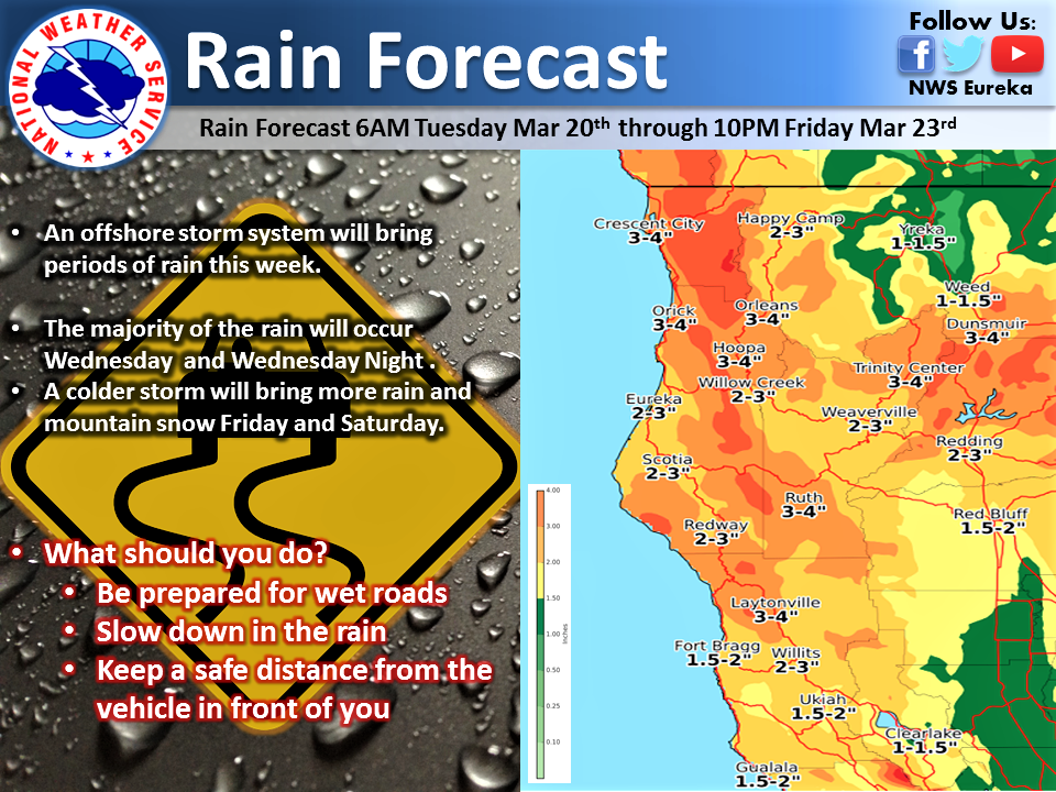
An unusually cold and wet system for late March is expected to move into our area Thursday night and Friday. A strong cold front will move through late Thursday with snow levels lowering to 2000 feet Thursday night and possibly as low as 1000 feet by Friday morning.
At the same time, an atmospheric river will take aim at the coast near the California Oregon border and bring a lot of moisture to the area. The combination of cold air and heavy precipitation will lead to the potential for heavy snow accumulations.

The focus of heavy snow looks to be in the mountains of Curry, Josephine, and west-central Siskiyou counties and into the Cascades. This includes Interstate 5 near Mt. Shasta and Siskiyou Summit. However, significant snow accumulations will be possible over the lower elevations as well, including the passes along Interstate 5 between Grants Pass and Roseburg.
Valley locations may see slushy accumulations at times. The greatest chance to see significant snow accumulations on roadways in all areas will be at night. During the daytime, snow levels will rise and most roadways will be wet due to strong March sun.
While it is too early to get specific on snow amounts, residents and travelers through northern California and southern Oregon should be prepared for the possibility of significant travel impacts from snow from late Thursday through Friday, especially in the mountains and at night.
Please Like, Share and Follow the …
![]()